 Florida Department of Environmental Protection
Mitigation Bank Service Area Map
More Information | Mitigation Banking Website
To find mitigation banks you can either:

- Click on the map OR
- Enter an address in the search box

 Florida Mitigation Bank Service Area Map
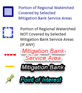
Purpose: This map was created to depict the Mitigation Bank Service Areas permitted by the State of Florida. If a service area is larger than the regional watershed in which the Mitigation Bank is located, a darker shade will represent the service area within the regional watershed and the lighter shade will represent the service areas outside of the regional watershed. Regional Watersheds are defined in 62-342.200(9) Florida Administrative Code (F.A.C.). To offset adverse impacts, mitigation credit requirements may be higher if an impact occurs within the Service Area but outside the Regional Watershed, 62-342.600(6) F.A.C. If you have any questions please, contact your local permitting office or FDEPMitigationBankTeam@dep.state.fl.us.
Results to Expect: By entering an address or selecting a location on the map, banks that provide mitigation coverage to the entered location will be displayed. Results are divided into two different categories, inside and outside the regional watershed. Bank contact information and a link to their webpage will be displayed for the mitigation banks returned in the results. Contact the mitigation bank representative and/or visit their webpage to learn more about credit availability.